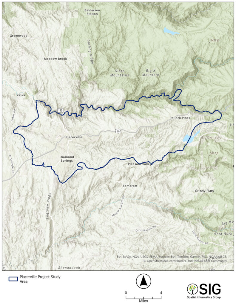
The project team integrated technical GIS modeling with applied planning by collating and mapping extensive treatment records from community organizations, utilities, and government agencies. This systematic approach allowed for the incorporation of existing treatments into a coordinated, multi-pronged plan.
An important part of this methodology was the use of previous reports including much of their analyses, language, and suggestions for planning efforts. For example, the Greater Placerville Wildfire Evacuation Preparedness, Community Safety & Resilience Study was used to outline the study area and proved several worst-case wildfire scenarios that could severely impact the built environment. The research team aimed to efficiently address the wildlife issue in western forests by utilizing the most effective components of existing reports and plans, rather than developing an entirely new approach. This primarily included:
Such efforts, combined with SIG’s novel approach to mapping and assessing risk in the wildland-urban interface (WUI), identified areas offering the most immediate and long-term improvements, prioritizing those that provide the greatest benefit per investment.
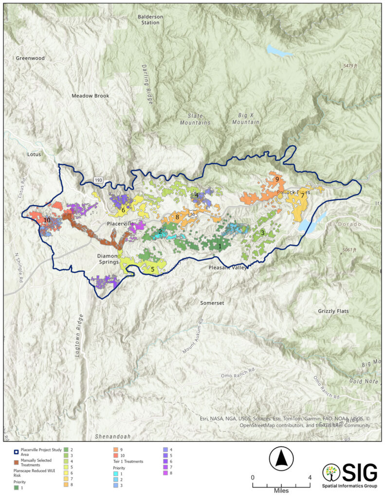
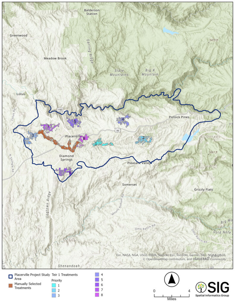
The Planscape treatment outputs confirmed and augmented priority treatment areas by showing a strong overlap with the 12 locations identified in the manual suitability analysis and illustrating novel ways to connect those treatments. Additionally, manual adjustments were made for local nuances, like Weber Creek and the Jawbone neighborhood, as they were recognized as high priority by local stakeholders, including fire chiefs–emphasizing that local expertise is invaluable to such a process.
Maps were provided to community members to mark areas of concern, which were cross-checked in the suitability analysis. Happily, the project’s analysis accurately addressed community concerns, thereby bolstering the credibility and acceptance of the project outcomes within the community.

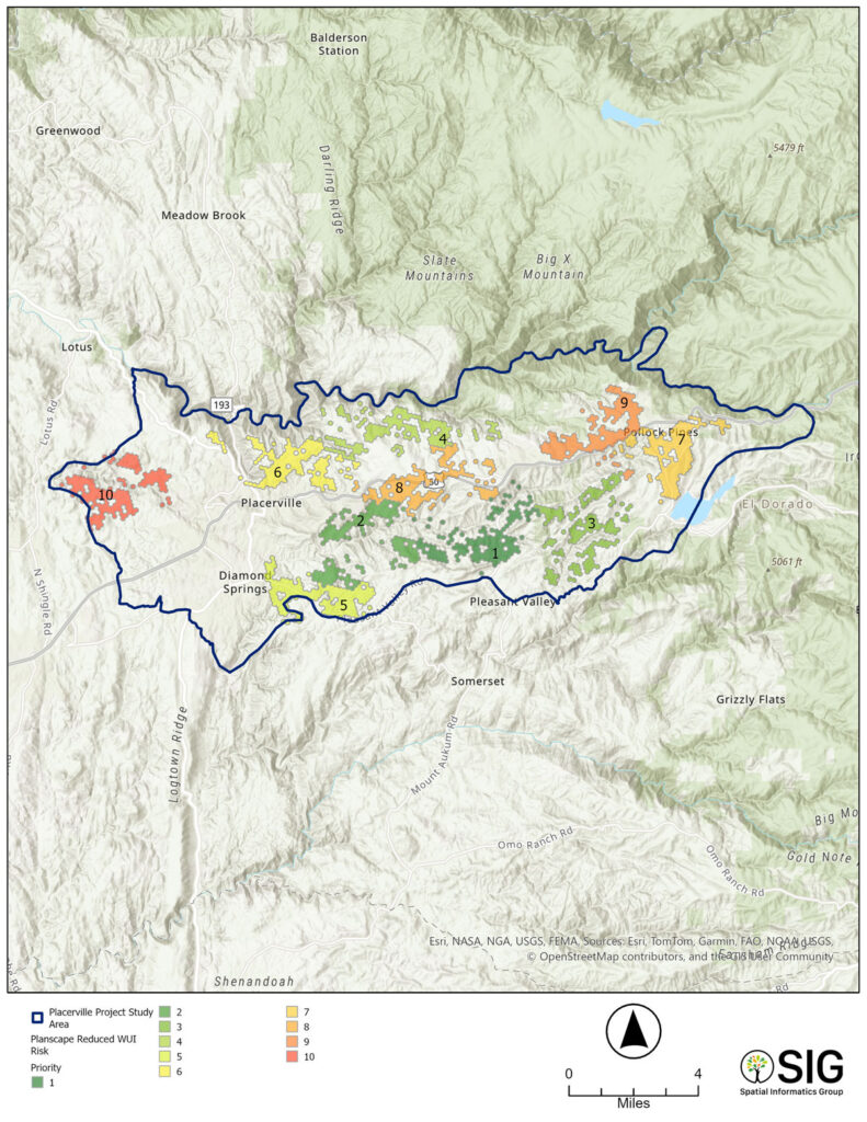
Figure 2: Map 1 – displaying Planscape reduced risk in WUI.

Figure 3: Map 2 – displaying Map 1 overlaid with Tier 1 treatments from suitability model and manual treatments.


Figure 5: Final map of the Placerville Project Study Treatments from the Placerville Wildfire Resilience Strategy website.
The Placerville Wildfire Resilience Strategy showcases how Planscape transforms wildfire planning from complex analysis into coordinated community action. By combining local knowledge with advanced modeling, the team used Planscape to identify and prioritize 60,000 acres of fuel reduction opportunities, linking neighborhoods, infrastructure, and ecosystems into a single, data-driven strategy.
Planscape’s open, transparent platform allowed local agencies, utilities, and residents to visualize wildfire risk, validate results, and guide investment decisions together. This clarity and trust helped unlock $10 million in CAL FIRE funding to implement priority treatments, marking a significant step toward reducing wildfire risk across El Dorado County.
The project also shaped Planscape’s continued evolution. Insights from Placerville directly influenced new features in innovations like treatment “cards,” retreatment scheduling, and community map feedback, ensuring the platform keeps meeting real-world needs. Today, this same collaborative framework is being replicated by partners like the Amador RCD, proving Planscape’s scalability and value in building regional wildfire resilience.
Planscape bridges science, technology, and community to turn planning into progress.
In Placerville, by layering manual and Planscape suitability modeling and validation, the team built a shared framework that helped unify diverse data sources, guided local decision-making, and built confidence among residents and agencies alike. The result was not just a plan on paper, but a shared roadmap that secured funding, accelerated implementation, and strengthened trust in the process.
By empowering communities to visualize risk, test strategies, and act together, Planscape is redefining how wildfire resilience planning happens: locally led, data-informed, and impact-driven.